Software
 
The Society for the Geosciences applications of Geostatistics and Neural Networks  
   GeoNeurale  |GeoNeurale Wavefields  |  News   |  Abstracts  |   Courses   |  Courses Schedule  |  Consulting - Geosystems Engineering Contact
   
 
SOFTWARE


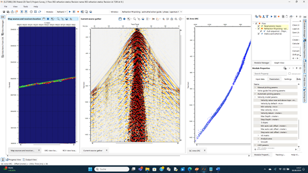
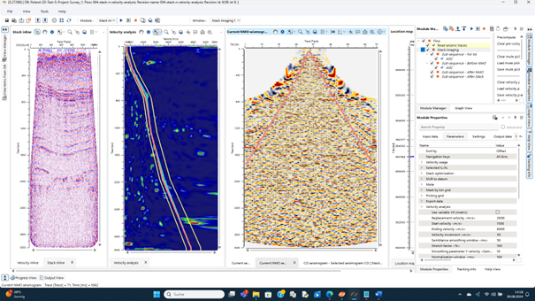
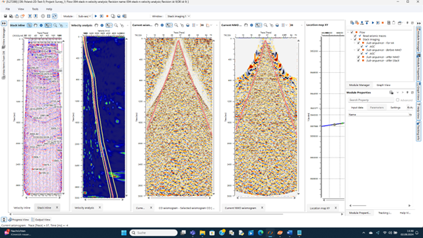
GEOMAGE  ( @Geomage )

QC SEISMIC PROCESSING SOFTWARE -


We tested the Geomage g_platform for seismic processing. The Geomage g_Platform is the State of the Art in the domain of seismic processing softwares. A powerful system that will enhance the imaging and resolution of the 3D seismic data. This system can perform sequential operations where the processing workflow can be organized in loops and subsets of seismic-loops, which allow the processing specialist to compare different algorithms or modules finalized for the upcoming quality control of velocity analysis.


For the most critical part of the processing on the early refraction statics stage, three methods are available: first-break picking regression, tomographic refraction statics and cross-correlation refraction statics. This allows an early QC on the performance and optimal results on the NMO correction and brute stacks.


For linear noise attenuation and multiple attenuations a variety of algorithms are available for all possible experiments that will bring to the best results.


Velocity Analysis (v) come with a variety of modules: stack Imaging, v Analysis, horizontal v Analysis, velocity model. These powerful methods allow an efficient data QC through semblance, optimal analysis for multiple attenuation, azimutal control for anisotropy and AVO, QC on vertical, horizontal, azimuthal velocities with sonic logs for reservoir parametrization.


The most powerful and innovative that this platform set available for the processor are: Multifocusing Technology, Diffraction Imaging and Migration Imaging PreSDM.


Multifocusing. This processing phase in the zero-offset approximation is performed on a prestack seismic data volume of common shot gather by wave separation of plane waves reflections and point wave produced by small scale diffractors. It is particularly important to increase the fold in the binning process therefore increasing the signal to noise ratio. A further enhancement consist in the introduction of a common offset MultiFocusing to take into account of the non-hyperbolic traveltime surfaces with higher order moveout where the 4th order is related to the Epsilon and Delta Thomsen parameters. The process is also performed on a super-garther and can be applied to higher curvature reflectors.


Diffraction Imaging. Imaging and resolution enhancement in seismic processing for geothermal projects are perhaps the most important step of the interpretation process. Diffraction imaging can delineate small scale heterogeneity, high curvature structures and faults. Diffractions appear on the common offset gathers and common image gathers with non-hyperbolic moveout and a quasi-plateau in the proximity of the zero offset (E. Rubein). An enhancement of the scattered or diffraction energy is obtained by attenuation of the specular events, thus subtracting the reflected wave from the total signal in the prestack domain. This creates a diffraction energy attribute and a diffraction coherency attribute. With a velocity model it is possible to produce synthetics of seismic gathers containing both reflected and refracted waves, where the refracted waves have significantly lower energy content then the reflections. Afterwards a normal moveout correction can be applied to the gather only for the reflections, therefore automatically separating the diffractions. The result of the diffraction imaging is a full azimuth seismic image which primarily contains optimally stacked diffraction events.


PreSDM and Stereo Tomography Prestack Depth Migration needs the optimal Vrms Velocity model produces in time Domain to extract the Dix interval velocities to create a depth Velocity model and from Kirchhoff PreSDM create the CIG. Stereo Tomography updates the Depth Velocity model.


g_Platform also calculates a range of seismic Attributes for Interpretation purposes. These are: Instantaneous Attribute , SN Ratio, spectral attributes.


FRACA  ( Beicip-Franlab )

FRACA V will be the result of the FRACA++ project which aims to develop the next generation of fracture characterization and modeling tool.

FRACA V will be built as a modern, ergonomic, easy to use geomodeling tool. It will use geological, geophysical and dynamic data to fill reservoir grids with parameters that will allow users to take into account fault and fracture behavior to perform dynamic reservoir simulations. Special care will be laid on the use of 3D seismic and geomechanical attributes to control the distribution of fractures. It will handle complex grid systems including CPG grids. Effective 3D fault and fracture simulation will be necessary to be compatible with CPG grids and non layered models. FRACA V will benefit from the progresses made by IFP research teams concerning the simulation of dynamic data on DFN’s, to further develop FRACA’s leading dynamic calibration approach. Finally, the users of FRACA V will be guided if needed by default workflows, including a fast track workflow for quick-look field studies.


THEMIS  ( Beicip-Franlab )


Accurately quantifying petroleum system effectiveness from preliminary exploration to field development stages while honoring operational requirements through flexible and upgradable workflows.

As shown by recent achievements in the most challenging oil provinces, Temis3D applicability ranges from regional quantitative prospect assessment to pre-drill pore pressure prediction.

Temis3D's modular packaging, its integration with 1D and 2D modeling capabilities, and its links to third party software applications ensures Temis3D adaptability to various situations according to data availability and technical issues to be addressed.

The long and unmatched leading scientific research of the Institut Français du Pétrole brings to Temis3D's algorithms the required technical excellence to capture the complexity of sedimentary basin evolution.


RML  ( Beicip-Franlab )

RML is a unique suite of advanced solution for geologists, geophysicists and reservoir engineers. RML suite is composed of 4 integrated and independent modules:

RML-GeoSurf is based on an interactive interface for building accurate 3D structural frameworks, whatever the fault surface geometry.

RML-GeoSim buids high resolution corner-point geometry reservoir grids based on the structural framework and honouring stratigraphic rules and flow unit definitions RML-GeoSim also offers a large variety of deterministic and stochastic techniques to populate grids with lithology and petrophysics. In particular, geological facies simulations allow integrating various constraints (logs, seismic and sedimentological model). RML-GeoSim features a true and efficient link to the ISATIS geostatistical toolbox from Geovariances.

RML-SimGrid is an intuitive reservoir grid builder that generates corner point geometry and XY-ortho grids based on structural framework and stratigraphic interpretations. RML-SimGrid benefits from advanced grid refinement functionalities.

RML-SimUp is a versatile topologic and geometric upscaling solution that populates the corner point geometry grid obtained with RML-SimGrid with petrophysical properties from high resolution geological models. The proposed layer based approaches even preserve thin geological features.


GeoNeurale